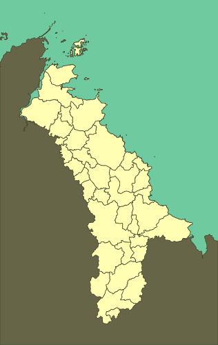
The Goelo can be defined by the administrative limits of 38 communes:
Binic, Cohiniac, Étables-sur-Mer, Île-de-Bréhat, Kerfot, La Méaugon, Lanleff, Lanloup, Lannebert, Lantic, Lanvollon, Le Fœil, Paimpol, Plaine-Haute, Pléguien, Pléhédel, Plélo, Plérin, Plerneuf, Ploubazlanec, Plouézec, Plouha, Plourhan, Plourivo, Plouvara, Pludual, Pordic, Quintin, Saint-Donan, Saint-Quay-Portrieux, Trégomeur, Tréguidel, Tréméloir, Tréméven, Trémuson, Tressignaux, Tréveneuc, Yvias.
Summary
| name |
surface |
population |
density |
| Binic |
5.83 |
3 825 |
656 |
| Cohiniac |
12.55 |
407 |
32 |
| Étables-sur-Mer |
9.25 |
3 022 |
327 |
| Île-de-Bréhat |
3.5 |
406 |
116 |
| Kerfot |
5.82 |
691 |
119 |
| La Méaugon |
6.75 |
1 292 |
191 |
| Lanleff |
2.22 |
111 |
50 |
| Lanloup |
2.54 |
264 |
104 |
| Lannebert |
7.06 |
451 |
64 |
| Lantic |
15.89 |
1 659 |
104 |
| Lanvollon |
5.07 |
1 749 |
345 |
| Le Fœil |
21.89 |
1 491 |
68 |
| Paimpol |
24.03 |
7 298 |
304 |
| Plaine-Haute |
15.87 |
1 515 |
95 |
| Pléguien |
15.74 |
1 282 |
81 |
| Pléhédel |
12.69 |
1 290 |
102 |
| Plélo |
44.6 |
3 301 |
74 |
| Plérin |
27.66 |
14 394 |
520 |
| Plerneuf |
8.53 |
1 016 |
119 |
| Ploubazlanec |
15.45 |
3 057 |
198 |
| Plouézec |
28.56 |
3 259 |
114 |
| Plouha |
41.49 |
4 505 |
109 |
| Plourhan |
17.24 |
1984 |
115 |
| Plourivo |
28.36 |
2 224 |
78 |
| Plouvara |
22.95 |
1 133 |
49 |
| Pludual |
9.62 |
749 |
78 |
| Pordic |
28.83 |
6 088 |
211 |
| Quintin |
3.12 |
2 822 |
904 |
| Saint-Donan |
22.94 |
1 453 |
63 |
| Saint-Quay-Portrieux |
4.42 |
2 995 |
678 |
| Trégomeur |
10.8 |
931 |
86 |
| Tréguidel |
6.68 |
604 |
90 |
| Tréméloir |
4.8 |
797 |
166 |
| Tréméven |
5.18 |
345 |
67 |
| Trémuson |
6.29 |
1 981 |
315 |
| Tressignaux |
7.39 |
659 |
89 |
| Tréveneuc |
6.76 |
773 |
114 |
| Yvias |
11.75 |
759 |
65 |
| Total |
530.12 |
82 582 |
156 |
Note: surfaces are expressed in square kilometers
Source: Populations légales 2013, INSEE (2013)
